")
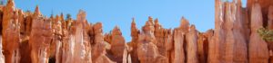
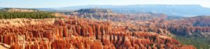
Bryce Canyon National Park is perhaps one of the most unique geologic formations in the world. Bryce Canyon, named for the pioneer farmer and rancher Ebenezer Bryce, is actually series of amphitheaters on the edge of the Paunsaugunt Plateau. The color of Bryce Canyon is the result of Iron oxidization and constant erosion has created the magnificent formations that are visible today in the limestone rock of the region. Winter freezing and summer thaws have broken down the rock and left thousands of spires, fins, arches and mazes. These formations called “hoodoos,” take on every imaginable shape and hue.
Ebenezer Bryce referred to the area as “one hell of a place to lose a cow.” The Piute Native American Tribes of south-central Utah, call the Bryce Canyon area Unka-timpe-wa-wince-pockich, which means “red rocks standing like men in bowl shaped canyon.” The National Park Service has given areas within the park mystical names, such as Fairy Land Canyon, Queen’s Garden and Swamp Canyon. No matter what you call it; Bryce Canyon National Park is unlike anything you have ever seen before.
Bryce Canyon National Park isn’t really a canyon at all; it is more of a horseshoe-shaped amphitheater filled with limestone, sandstone, and mudstone pillars called hoo-doos. Visitors to the area will find more than 35,800 acres of juniper forest; winding trails that travel past the coral and beige colored hoo-doos and a mosey cave, which is feed by an underground stream.
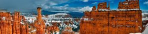
Apart from being a canyon that’s not a canyon, Bryce National Park is also located in an area known for its unusual weather patterns. Freak snowstorms in the middle of July are not uncommon; neither are warm sunny days during the winter season. Visitors to Bryce Canyon should remember to pack for any weather conditions, no matter what time of year they plan a trip.
Bryce Canyon is visited by approximately 1.7 million people on an annual basis. Visitation peaks from June through September and is at its lowest in December, January and February. Summer visitors to the park will find it most quiet in the earlier and later hours of the day. The visitor center is open year round and offers a brief slide program along with exhibits, restrooms, information, and backcountry permits.
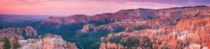
You may choose to drive along the 18-mile main park road that winds along the edge of the plateau. This road terminates at the south end of the park where one can see nearly 100 miles in the distance in many directions. The air in the park is usually very clear and sunrises and sunsets are particularly beautiful in this area. Many side roads or pullouts offer visitors the opportunity to stop and view unique formations in each of the many amphitheaters. All of Bryce Canyon’s viewpoints are east of the main park road so it is convenient to first drive the 18-mile road to the southern end of the park and then start with Rainbow Point and work your way back to the entrance of park.
Bryce Canyon offers two campgrounds and there are several private campgrounds just outside the park. The park sites fill by early afternoon during the summer months.
Bryce Canyon is best experienced by going down inside the park. This can be accomplished in several ways. You may hike down, ride horseback or even take a scenic plane or helicopter ride outside along the outer rim. Remember that Bryce ranges in elevation from 8,000 to 9,000 feet and walking trails are quite steep. The walk down will be easy but the walk back up requires some effort. It is definitely worth the time and the effort, but remember to bring layers of clothing for varying temperatures and also bring plenty of water to drink.
